|
⇒ Welcome ⇒ e-mail contact | ||
| ||
| ||
| ||
|
⇒ Cover ⇒ Preface ⇒ Introduction ⇒ The visit ⇒ Weymouth map c.1930 ⇒ Portland map c.1930 ⇒ Works quoted ⇒ Postface |

|
A visit to Weymouth with John Cowper Powys [ ⇒
return... ]
|
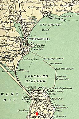
THE "GIBRALTAR OF WESSEX"This view taken from Tout's Quarry shows on the left the curve with which Chesil Beach begins, and beyond the town of Chesilton, Portland Harbour and the Breakwater, with the East Ship Channel visible to the right, and beyond in the distance the coast of Weymouth Bay. Portland is 4.5 miles in length, from 1.5 to 1.75 miles wide, and rises at the North end at the Verne Hill and Citadel to a height of 500 feet, sloping down rapidly to 20 feet above sea-level at the Bill, its southern tip. The Breakwater took 23 years to build, from 1849 to its inauguration in 1872, with extensive use of convict labour. |
[ ⇒ return... ] |