|
⇒ Welcome ⇒ e-mail contact | ||
| ||
| ||
| ||
|
⇒ Cover ⇒ Preface ⇒ Introduction ⇒ The visit ⇒ Weymouth map c.1930 ⇒ Portland map c.1930 ⇒ Works quoted ⇒ Postface |

|
A visit to Weymouth with John Cowper Powys [ ⇒
return... ]
|
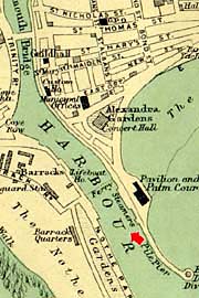
WEYMOUTH HARBOURA map corresponding to this view from the upper deck of the car-ferry from Cherbourg looking SW into the harbour. The Weymouth lifeboat is visible at its moorings which have remained at the point indicated on the map. Weymouth is in fact made up of the ancient Weymouth to the left of the harbour on the map, which used to be devoted to the manufacture of beer, and Melcombe Regis to the right where the railway station, hotels and Esplanade are to be found. The rivalry between the two boroughs ended when Elisabeth I united them by Act of Parliament. They were connected by a bridge with the result that together they grew "very much greater and goodlier in buildings and by sea adventures." (Camden). |
[ ⇒ return... ] |